MAP: Which parts of Paris region are most vulnerable to heatwaves?
A new study has found that millions of residents in the Paris region are particularly vulnerable to heatwaves, due to a combination of city architecture that traps heat and economic problems which mean that cannot protect themselves effectively.
A new study by the Paris Region Institute mapped out which inhabitants of the region are most affected by heatwaves, and it found that more than 6,000,000 people - over half the residents of Île-de-France - live in 'urban heat islands', with some experiencing particularly high-risk when it comes to heat.
The urban heat island phenomenon refers to cities being hotter than surrounding countryside during heatwaves, due to a combination of human activities, concrete surfaces that reflect heat, and heat pollution such as air conditioning units and cars.
READ MORE: Essential French vocab for a heatwave
It also leads to significantly warmer nighttime temperatures, as heat accumulates during the day but cannot escape in the same way it might in a field, for instance - making for sticky nights that make it hard to sleep and increase the effects of heat stress, especially in the elderly or ill.
Sometimes the difference in temperature can be as much as 8C to 10C between the city and the countryside, as a result of the urban heat island effect.
Researchers also looked into risk levels within 'heat islands', in an effort to better protect local populations living in them, and created a map showing the differences in vulnerability between individual neighbourhoods within the region.
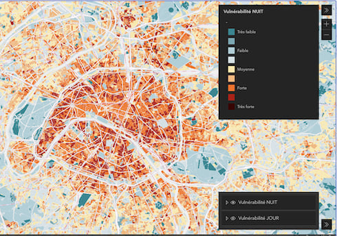
Map Credit: Paris Region Institute
Which areas are most vulnerable to heat?
The Paris Region Institute came up with an index to determine an area's vulnerability to the impacts of the heat island effect, resulting in a score ranging from one (blue, very low vulnerability) to nine (red, very high vulnerability).
From policymakers to local inhabitants, anyone can click on the map they created to see the difference from one street to another. Users can also compare an area's vulnerability to heat at nighttime versus daytime, and they can click to see the map separated by each of its criteria.
READ MORE: Grass roofs and siestas: How Paris is preparing for the day temperatures hit 50C
The first criteria looks at how built up a neighbourhood is and whether there are green spaces, while the other two look at the populations themselves.
The second criteria asks what proportion of inhabitants are vulnerable (the very young and the very old), while the third considers the residents' 'ability to cope'.
This would include their socio-economic status and ability to escape the city during high temperatures, as well as access to medical professionals and wait-times for emergency services.
In Paris many of the middle and upper classes leave the city in the summer, especially in August, leaving some parts largely deserted. However people on lower incomes are less likely to be able to afford a holiday, and more likely to work in sectors that don't close down over the summer, such as retail, sanitation and healthcare.
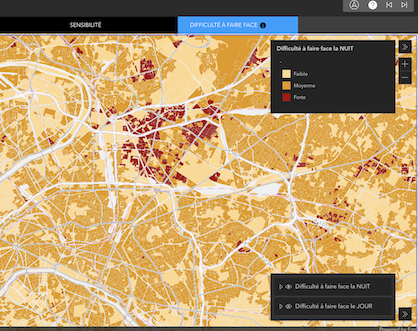
A zoomed in version of the map, showing the Seine-Saint-Denis area based on the third criteria. (Credit: Paris Region Institute)
The study found that working class areas "such as the 18th, 19th, and 20th arrondissements, as well as part of the 10th arrondissement, the Seine-Saint-Denis and Val-de-Marne départements remain more populated during the summer", Erwan Cordeau, a climate specialist in the Environment Section for the Paris Region Institute, told Le Parisien.
The map also allows users to click on those individual communes and areas to see more specific information, including the number of particularly vulnerable people (as shown below).
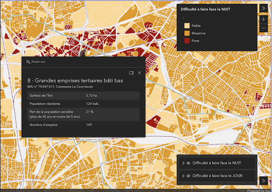
Specific information for Commune La Courneuve in Seine-Saint-Denis (Credit: Paris Region Institute)
The overall results found that even though half of all Île-de-France residents live in a 'heat island', almost a third of people - or 3,685,000, live in areas that are highly vulnerable, including over 845,000 people at particular risk due to old age.
The Paris region - Île-de-France - covers an area of over 12,000 km squared, representing just 2.2 percent of the national territory but home to almost 20 percent of the country's total population.
Comments
See Also
A new study by the Paris Region Institute mapped out which inhabitants of the region are most affected by heatwaves, and it found that more than 6,000,000 people - over half the residents of Île-de-France - live in 'urban heat islands', with some experiencing particularly high-risk when it comes to heat.
The urban heat island phenomenon refers to cities being hotter than surrounding countryside during heatwaves, due to a combination of human activities, concrete surfaces that reflect heat, and heat pollution such as air conditioning units and cars.
READ MORE: Essential French vocab for a heatwave
It also leads to significantly warmer nighttime temperatures, as heat accumulates during the day but cannot escape in the same way it might in a field, for instance - making for sticky nights that make it hard to sleep and increase the effects of heat stress, especially in the elderly or ill.
Sometimes the difference in temperature can be as much as 8C to 10C between the city and the countryside, as a result of the urban heat island effect.
Researchers also looked into risk levels within 'heat islands', in an effort to better protect local populations living in them, and created a map showing the differences in vulnerability between individual neighbourhoods within the region.
Which areas are most vulnerable to heat?
The Paris Region Institute came up with an index to determine an area's vulnerability to the impacts of the heat island effect, resulting in a score ranging from one (blue, very low vulnerability) to nine (red, very high vulnerability).
From policymakers to local inhabitants, anyone can click on the map they created to see the difference from one street to another. Users can also compare an area's vulnerability to heat at nighttime versus daytime, and they can click to see the map separated by each of its criteria.
READ MORE: Grass roofs and siestas: How Paris is preparing for the day temperatures hit 50C
The first criteria looks at how built up a neighbourhood is and whether there are green spaces, while the other two look at the populations themselves.
The second criteria asks what proportion of inhabitants are vulnerable (the very young and the very old), while the third considers the residents' 'ability to cope'.
This would include their socio-economic status and ability to escape the city during high temperatures, as well as access to medical professionals and wait-times for emergency services.
In Paris many of the middle and upper classes leave the city in the summer, especially in August, leaving some parts largely deserted. However people on lower incomes are less likely to be able to afford a holiday, and more likely to work in sectors that don't close down over the summer, such as retail, sanitation and healthcare.
The study found that working class areas "such as the 18th, 19th, and 20th arrondissements, as well as part of the 10th arrondissement, the Seine-Saint-Denis and Val-de-Marne départements remain more populated during the summer", Erwan Cordeau, a climate specialist in the Environment Section for the Paris Region Institute, told Le Parisien.
The map also allows users to click on those individual communes and areas to see more specific information, including the number of particularly vulnerable people (as shown below).
The overall results found that even though half of all Île-de-France residents live in a 'heat island', almost a third of people - or 3,685,000, live in areas that are highly vulnerable, including over 845,000 people at particular risk due to old age.
The Paris region - Île-de-France - covers an area of over 12,000 km squared, representing just 2.2 percent of the national territory but home to almost 20 percent of the country's total population.
Join the conversation in our comments section below. Share your own views and experience and if you have a question or suggestion for our journalists then email us at [email protected].
Please keep comments civil, constructive and on topic – and make sure to read our terms of use before getting involved.
Please log in here to leave a comment.